Hike to Summit Lake
We took the hike to Summit Lake which is the closets lake to Three Finger Jack on the south side. The trails follows the Pacific Crest Trail for about 6 kilometers, and then splits off for last half a kilometer on an unmaintained trail which was a little hard for us to find. We ended up passing the turn and trail blazed to a cliff that over looks Summit Lake, but with some perseverance and back tracking we found a route to Summit Lake. Overall, the hike was a nice short trek with some spectacular views.
This is a image of Summit Lake looking southwest. The cliff we found that overlooks summit lake is to the right but out the image.
The Start
The start of the trail is an access point to the Pacific Crest trail on Highway 20 in Central Oregon. We were thinking of bringing our drone but learned that the wilderness area is a no drone fly zone. The parking lot was full of horse trailers so we expected to encounter horses on the trail, and we did come across several on the trail.
Fields of Lavender
About a kilometer and a half into the hike we came to meadow that was full of lavender. There was a little pond at the north end of the meadow that Finn took a swim in, and at end of the meadow the trail splits. The left trail (Trail 3491) which would take you the Eights Lakes Basin or the Marion Flats, and the right trail is the Pacific Crest Trail which will take you to Summit lake or Canada.
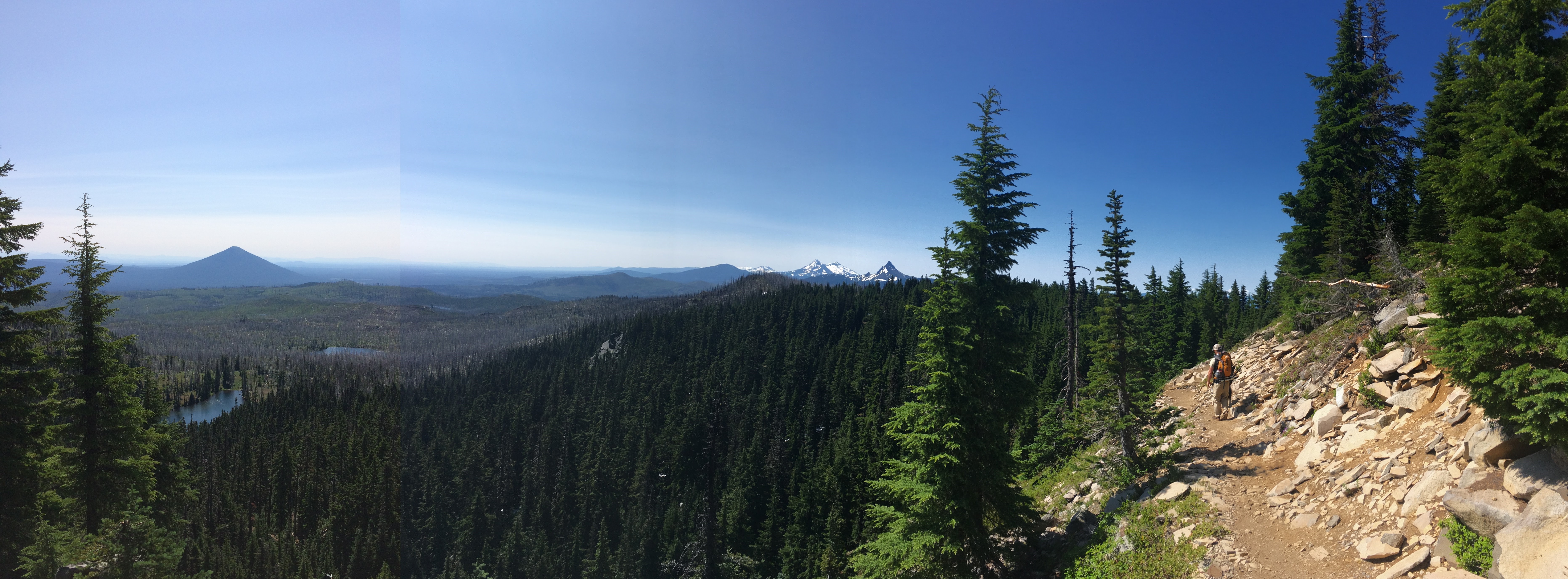
Switchback
There is only one real switchback on this hike which brings you up to the Casaide Divide. The view from here is pretty sweet- to the south you can see the Three Sisters, Mount Washington and maybe Mount Bachelor. I was also testing out my new black river shoes for creek crossings, and by this point they were a solid brown.

The Ever Vigilant Finn
Along the ridge we hit the unburnt tree line (about 5 kilometers into the hike). The tree shade still had some snow pack which Finn was estatic to see. He learned to slide around on the snow to cool off, at least until he saw a another little creature to chase up a tree.
This Is Why I Hike!
About 5.8 kilometers into the hike is a section that cuts across a steep side of the bottom of Three Finger Jack. This steep slope gives the most dramatic view of the trek, showing Mount Washington, the Sisters, Mount Bachelor and Black butte on the far left. However, just ahead is where the trail splits so keep your eyes peeled for trails on the right. If your bearing after this point turns West you have gone to far and missed the turn to Summit Lake.
Summit Lake
After 6.5 kilometers, along with a few detours, we made it to Summit Lake. The lake was cold as expected, and sadly no fish. But due to the obscurity of the trail no other hikers were there and we camped in solitude.

.